Medellin metro is the only subway system in Colombia. It has 2 surface lines, A and B,
that cross the city from north to south and from downtown to west and 3 metrocable lines (cable car system),
K, L and J, that cross the city from north to west and from west to northwest.
The system is complemented by Metroplus and serves all Medellin metropolitan area, a distance of about 64 kms.
- Known as: Metro
- Lines: 2 ( and 3 metrocable lines more)
- Stations: 28
- Length: 32 km of metro lines and 64kms including metrocable,metroplus and metro
- Web: www.metrodemedellin.gov.co
- Opening: November 30, 1995
- Passengers/year: 155 millions (2008)
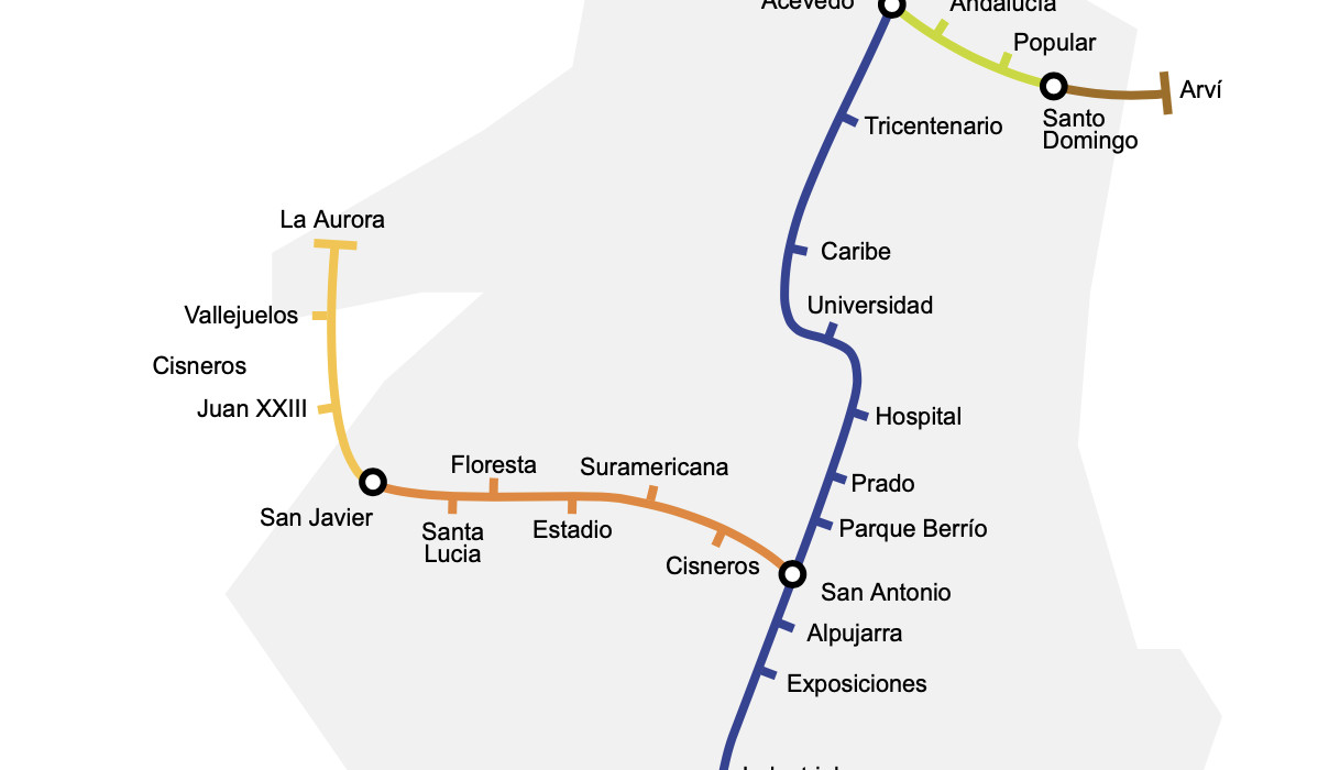
Lines and stations
Lines A and B are metro lines.
- Line A. This line crosses Medelling from Nort to South. Length of the line: 23.2 km. 21 stations:
Niquia, Bello, Madera, Acevedo Linea K, Tricentenario, Caribe, Universidad, Hospital, Prado, Parque Berrío, San Antonio, Alpujarra, Exposiciones, Industriales, Poblado, Aguacatala, Ayurá, Envigado, Itaguí, Sabaneta, La Estrella - Line B. Goes from downtown to west. Length 5,6 kms: 7 stations:
San Antonio, Cisneros, Suramericana, Estadio, Floresta, Santa Lucía, San Javier
Lines K,L and J are metrocable lines.
- Line K. Goes from north to north west. It has only 4 stations:
Acevedo, Andalucía, Popular, Santo Domingo Savio - Line L. Serves Medellin North East. It has 2 stations:
Santo Domingo Savio, Arví - Line J. Goes from west to north east. 4 stations.
San Javier, Juan XXIII, Vallejuelos, La Aurora
Schedule and frecuency
Medellin Metro is open from monday to sunday from 4:30 am to 10:45 pm. Sundays and holidays from 07.00 am to 10 pm.
It has a frecuency of 10 minutes, 3 minutes at rush hours.
Rates
1 trip – $ 1.500 (pesos colombianos)
Tarjeta Cívica: It’s a smart card.
Medellin Metro Map