Santiago has one of the most modern metro systems in Latin America and the second longest after Mexico, with 103kms of tracks. It was opened in 1975, so Metro de Santiago is also one of the oldests in South America. In mid-2013, works for lines 3 and 6 started. When this lines are completed, Metro de Santiago will have a total length of 140 kilometers and 136 stations.
- Known as: Metro
- System length: over 64 mi
- Lines: 5
- Stations: 108
- Top Speed: 50 mph
- Official Website: http://www.metrosantiago.cl/
- Operator: Metro S. A.
- Daily ridership: around 2.3 million passengers
- Air conditioning: no
- Start of operation: On May 29, 1969 began building the first line, which would link the Civic District and the area of Barrancas.
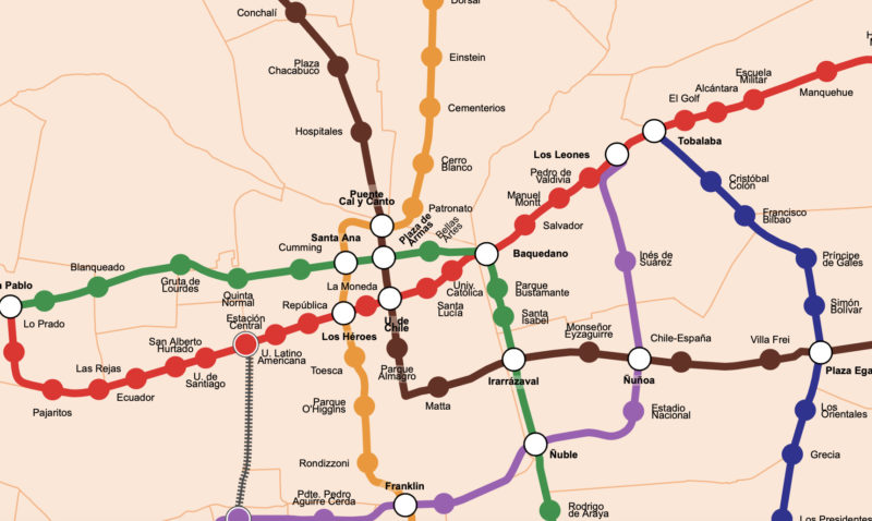
Santiago Metro: Lines and stations
LINE 1: From west to east, this line is the oldest line of the network. The complete route of the line 1 takes 29.7 minutes to travel. The Line 1 have 27 stations spanning the districts of Lo Prado, Central Station, Santiago, Providencia and Las Condes and it is identified with the color red. Stations: San Pablo, Neptuno, Pajaritos, Las Rejas, Ecuador, San Alberto Hurtado, Universidad de Santiago, Estación Central, Unión Latinoamericana, República, Los Héroes Santiago, La Moneda, Universidad de Chile, Santa Lucía, Universidad Católica, Baquedano, Salvador, Manuel Montt, Pedro de Valdivia, Los Leones, Tobalaba, El Golf, Alcántara, Escuela Militar, Manquehue, Hernando de Magallanes, Los Dominicos
LINE 2: From north to south through the towns of Recoleta, Santiago, San Miguel and La Cisterna. It comprises 22 stations and it is identified with the yellow colour. Stations: Vespucio Norte, Zapadores, Dorsal, Einstein, Cementerios, Cerro Blanco, Patronato, Puente Cal y Canto, Santa Ana Santiago, Los Héroes, Toesca, Parque O’Higgins, Rondizzoni, Franklin, El Llano, San Miguel, Lo Vial, Departamental, Ciudad del Niño, Lo Ovalle, El Parrón, La Cisterna, Lo Espejo, Observatorio, Lo Martínez, Hospital El Pino
LINE 3: From north to east. Metro Line 3 is currently planned for the coming years. It will have the following stations: Plaza de Quilicura, Las Torres, EFE Quilicura, Los Libertadores, Cardenal Caro, Vivaceta, Conchalí, Plaza Chacabuco, Hospitales, Puente Cal y Canto, Plaza de Armas, Universidad de Chile, Parque Almagro, Matta, Irarrázaval, Monseñor Eyzaguirre, Ñuñoa, Chile España, Diagonal Oriente, Plaza Egaña, Fernando Castillo Velasco, Hospital Militar
LINE 4 or blue line: This line serves to communities of the east and southeast area of Santiago, across the districts of Providencia, Las Condes, La Reina, Ñuñoa, Peñalolén, Macul, Florida and Puente Alto. The station has 23 stations and it is identified by the blue color. Estaciones: Tobalaba, Cristóbal Colón, Francisco Bilbao, Príncipe de Gales, Simón Bolívar, Plaza Egaña, Los Orientales, Grecia, Los Presidentes, Quilín, Las Torres, Macul, Vicuña Mackenna, Vicente Valdés, Rojas Magallanes, Trinidad, San José de la Estrella, Los Quillayes, Elisa Correa, Hospital Sótero del Río, Protectora de la Infancia, Las Mercedes, Plaza de Puente Alto
LINE 4A: From south to southeast, this line is a branch of Line 4. It passes through to the municipalities of La Florida, La Granja, San Ramon and La Cisterna. With just six stations is the shortest line of the network and it is identified by the light blue color. Stations: La Cisterna, San Ramón, Santa Rosa, La Granja, Santa Julia, Vicuña Mackenna
LINE 5: From southwest to southeast, this line have a total of 30 stations, being the longest of the network, pass through the communes of Maipú, Pudahuel, Lo Prado, Quinta Normal, Santiago, Providencia, Providencia, Macul, San Joaquin and Florida. It is identified by the green color. Stations: Plaza de Maipú, Santiago Bueras, Del Sol, Monte Tabor, Las Parcelas, Laguna Sur, Barrancas, Pudahuel, San Pablo, Lo Prado, Blanqueado, Gruta de Lourdes, Quinta Normal, Cumming, Santa Ana, Plaza de Armas, Bellas Artes, Baquedano, Parque Bustamante, Santa Isabel, Irarrázaval, Ñuble, Rodrigo de Araya, Carlos Valdovinos, Camino Agrícola, San Joaquín, Pedrero, Mirador, Bellavista de La Florida, Vicente Valdés
LINE 6: is expected to be operational in 2016. It’ll be the pink line. Stations: Lo Errázuriz, Cerrillos, Lo Valledor, Club Hípico, Franklin, Bio-Bío, Ñuble, Estadio Nacional, Ñuñoa, Inés de Suárez, Los Leones
Santiago Metro schedule and frequency:
Start to run at 5:30am and finish to 12:00am, it pass every 5 minutes.
Santiago Metro rates:
Rush hours: From 07:00 to 08:59 and from 18:00 to 19:59 it cost $ 670 (USD 1.41)
Valley hours: From 06:30 to 06:59; from 09:00 to 18:00 and from 20:00 to 20:44 it cost $ 610 (USD 1.28)
Low hours: From 06:00 to 06:29 and 20:45 to 23:00 it cost $ 590 (USD 1.24)
There are two ways of payment for use the service of the Santiago Metro: ticket or the smart card “Bip!”. These tickets can be purchased at the box office in all stations and in some shops nearby. The Bip! card is rechargeable at all ticket offices and other shops throughout the city. The card costs $ 1,350 (approx. USD 2.4) and the lowest charge is of $1,000 (approx. USD 1.6).
Connection to the airport
With a frequency of 10 minutes between arrives, Centropuerto buses are the cheaper alternative to travel to and from the International Airport of Santiago.
The Centropuerto buses are located next to the metro station of Los Heroes of the Line 1, the route has several stops.
The travel costs are $ 1,600 (USD 3.36) for the outward or back to the airport or $ 2,800 (USD 5.88) for the purchase of two transfers.
Curious facts about Santiago Metro
In March of 2012, it was chosen as the best subway system in America, after he was honored at the annual dinner of Metro Rail developed in London.
Santigo de Chile Metro Map

This post is also available in: French German Italian Spanish Portuguese (Brazil)